

Geospatial Applications Breaking Boundaries
The past 15 years have witnessed unprecedented advancements in the geospatial world. The future, as we see it now, appears more promising and inspiring than ever before.
Geospatial data has emerged as a crucial resource for decision-making, offering potential solutions to the challenges posed by the Sustainable Development Goals (SDGs). More powerful case applications are emerging across various sectors.
Open geospatial data serves as a valuable resource for understanding climate patterns, extreme weather events, and vulnerability assessments.
This information aids in developing effective climate adaptation and mitigation strategies, thus empowering policymakers to implement robust policies and measures to tackle the impacts of climate change.

Similarly, in the water and sanitation sector, geospatial data is instrumental in managing water resources, mapping watersheds, identifying flood-prone areas, assessing sanitation needs, and improving public health outcomes.
INNPACT SOLUTIONS, with support from AIT Global Water & Sanitation Center and other partners like InSol, have developed a Geospatial tool for City-Wise Inclusive Sanitation Plan that has been applied in over 25 cities across South Asia.
Currently, our team is developing a geospatial application decision support tool for Water-Sensitive Planning aimed at Climate Change Adaptation supported by Esri technologies. This tool may assist in locating suitable green and blue infrastructure, contributing to city aspirations of becoming resilient to climate changes such as floods, urban heat islands, groundwater depletion, eroding green cover, and polluted water bodies.
What’s happening in India ?
According to the India Geospatial Artha Report 2021, the Indian geospatial economy in 2021 is estimated to be approximately USD 1.9 billion (INR 14,050 crore). This sector has promising growth potential, with a projected value of approximately USD 3.1 billion (INR 23,200 crore) with an anticipated growth rate of 13.39% by the end of 2025.
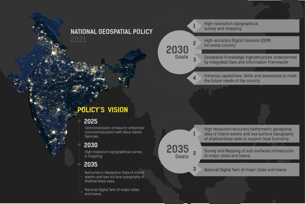
The Government of India introduced the Geospatial Data Guidelines in 2021 and National Geospatial Policy in 2022, which facilitated deregulation in the geospatial sector and provides a clear road map of actions.
The government also recognized the importance of GIS and Advanced Mapping Technologies such as LiDAR in infrastructure development and monitoring (like advocating LiDAR uses in all road/ highway project, forest surveys etc.), thus enabling accurate terrain surveying and mapping for improved planning, design, and construction.
Various initiatives are being undertaken, including mapping the entire Indian coastline to support activities such as Coastal Zone Regulation, Disaster Management, Infrastructure Planning, and Monitoring Coastal Changes.
Geospatial mapping played a crucial role in the Smart Cities Mission initiative of the Government of India by providing precise spatial data for urban planning, infrastructure development, and implementation of smart solutions and becoming a key operating functions of Integrated Control and Command System (ICCC).
Geospatial technology has been also driving inclusion and progress in national development projects like SVAMITVA (property survey in rural areas), PM Gati Shakti Master Plan (a multi-modal connvectivity project uniting 16 ministries), and the JAM trinity (key enabler of India’s transformed and well-developed digital landscape).
Data unavailability, confining the potential application?
As a GIS professional, I have been closely observed this evolving space. In most forums, a common question asked: “How are we going to acquire this massive amount of data for advanced GIS analysis?”
This blog post aims to increase awareness and understanding of the open geospatial data platforms available across developmental sectors. It also seeks to shed light on the next-generation thinking of AI applications within the geospatial realm.
Given the existence of massive data platforms, I’ve endeavored to focus on those with frequent usage and wider applications in identified sectors, with a larger emphasis on the Indian geospatial landscape.
Open Geospatial Initiatives
Globally, open geospatial data has already proven to be a game-changer. Initiatives such as OpenStreetMap, Microsoft Bing Spatial Data Services ESRI Open data hub have revolutionized the way maps are created and maintained.
Here are some notable initiatives of open geospatial data for various sectors:
General/Open Data Portals
1. OpenStreetMap: OSM is a collaborative mapping project that provides open access to geospatial data. While primarily a crowd-sourced mapping platform, OSM also incorporates AI techniques for tasks like road network extraction, building footprint detection, and land use classification. https://www.openstreetmap.org/

2. Open Government Data (OGD) India Platform: The Government of India’s OGD Platform provides access to various government datasets, including geospatial data. It allows users to explore and download open data related to diverse domains, contributing to transparency and enabling data-driven decision-making. https://data.gov.in/
3. ESRI Open Data Hub: Esri, a leading provider of Geographic Information System (GIS) software and solutions, supports and provides an open GIS data policy. Through the Esri Open Data Hub, users can explore and download a wide range of geospatial datasets contributed by organizations worldwide. https://www.esri.com/en-us/arcgis/products/arcgis-open-data

4. Global Human Settlement Layer (GHSL): The GHSL initiative, led by the European Commission’s Joint Research Centre, provides open geospatial data on human settlements worldwide. It includes data on population density, built-up areas, and other socio-economic indicators, supporting urban planning and development efforts. https://ghsl.jrc.ec.europa.eu/
5. OpenAddresses: OpenAddresses is a global collection of address data from various sources, providing data and information for geocoding and mapping purposes. https://openaddresses.io/
6. Microsoft Bing Maps – Building Footprints: Bing Maps has generated high-quality global level building footprints leveraging AI and harnessing the power of computer vision to detect building footprints from satellite imagery. It has released millions of building footprints as open data available to download free of charge. https://www.microsoft.com/en-us/maps/building-footprints

7. Google Maps – Open Buildings: Google Maps, a prominent provider of mapping services, plays a crucial role in enhancing and promoting open geospatial data. Leveraging its sophisticated deep learning tools, Google has curated a comprehensive dataset of building footprints, which serves as a valuable resource for various social good applications. https://sites.research.google/open-buildings/

Environment and Natural Resources:
1. USGS EarthExplorer: The USGS EarthExplorer is a portal for accessing various geospatial data from the United States Geological Survey (USGS). It includes aerial imagery, satellite data such as Landsat imageries, SRTM DEM, and more. https://earthexplorer.usgs.gov/
2. Copernicus Open Access Hub: Initiative of the European Commission and the European Space Agency (ESA) that provides accurate and up-to-date information about the Earth’s environment. Users can access and download satellite data, including the renowned Sentinel data, from a centralized portal. https://scihub.copernicus.eu/

3. Natural Earth: Natural Earth offers high-quality geospatial data such as global coastlines, bathymetry, rivers, and administrative boundaries, which can be freely used for mapping and other applications. https://www.naturalearthdata.com/
4. WorldClim: WorldClim offers high-resolution global climate data derived from weather station records and other sources .The data includes variables such as temperature, precipitation, humidity, solar radiation, wind speed, and more. https://www.worldclim.org/
5. Global Forest Watch: Online platform that provides near real-time monitoring and analysis of global forests. The platform uses satellite data, remote sensing technology, and crowdsourced information to track changes in forest cover, deforestation, forest fires, and other forest-related data. https://www.globalforestwatch.org/
6. FAO GeoNetwork: Developed by the Food and Agriculture Organization of the United Nations (FAO) to provide access to geospatial information and data related to agriculture, food security, and rural development. It serves as a repository and a catalog of spatial datasets, maps, and other geospatial resources. https://data.apps.fao.org/
7. NASA Earth Observing System Data and Information System (EOSDIS): EOSDIS provides access to a wide range of geospatial data related to Earth’s land, atmosphere, oceans, and other natural processes. It includes satellite imagery, climate data, and environmental information, supporting scientific research and applications worldwide. https://www.earthdata.nasa.gov/eosdis
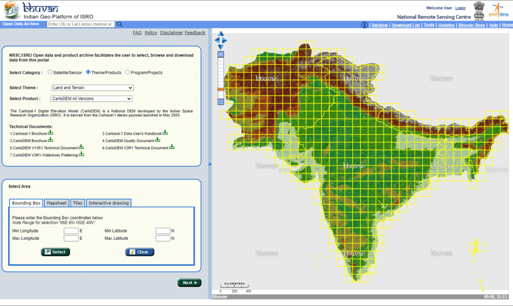
8. Bhuvan India: The Bhuvan initiative, launched by the Indian government, is a geospatial platform that provides satellite imagery and mapping services. The Open Data initiative of Bhuvan provides free access to datasets such as satellite imagery, thematic maps, and geospatial layers related to infrastructure, agriculture, environment, and more. https://bhuvan.nrsc.gov.in
Transportation:
1. OpenMobilityData: OpenMobilityData is a community-driven platform that hosts and shares public transport data in General Transit Feed Specification GTFS) format. It offers a repository of GTFS feeds from different cities, allowing users to access and download public transport data for various locations. https://transitfeeds.com/
2. Transitland: Transitland is an open data platform that aggregates and standardizes public transport data from various global sources. It provides a unified API for accessing transit data, including schedules, routes, stops, and more. https://www.transit.land/
3. DataSpace.mobi: A unified DataSpace portal for Urban Mobility in India that will enable sharing of standardized, high quality urban transport related datasets among various stakeholders. This initiative is supported by the India Smart Cities Fellowship Programme. https://dataspace.mobi/

4. Indian Cities GTFS data: The Open Government Data Platform of India (https://data.gov.in/) offers a wide range of datasets, including public transport data. Cities such as Bangalore, Delhi, Kochi, Bhubaneshwar and Jaipur have their own portals for accessing public transport data.
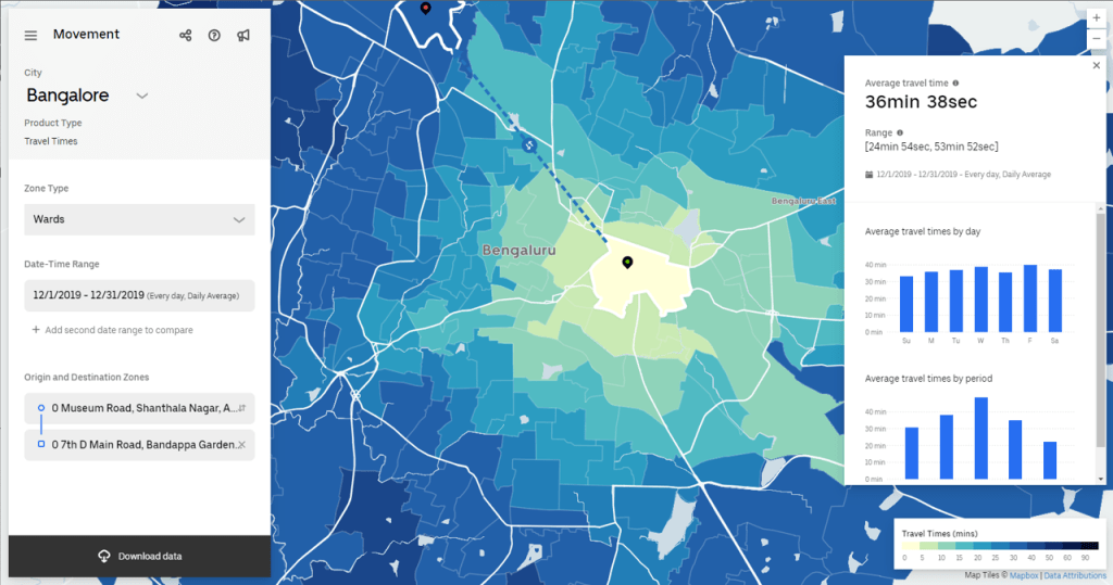
5. Uber Movement: Uber has launched the Uber Movement platform, which provides access to aggregated and anonymized data on travel times within specific cities. The platform shares anonymized data derived from over ten billion trips, aiding urban planning efforts worldwide. https://movement.uber.com/
Health:
1. Global Health Observatory (GHO) – World Health Organization (WHO): GHO provides geospatial data on various health indicators, including disease burden, healthcare resources, and health infrastructure at global and country levels. https://www.who.int/gho/en/
2. Healthsites.io: Healthsites.io is a global dataset of health facility locations, including hospitals, clinics, and pharmacies. It’s mission is to improve access to healthcare. https://healthsites.io/
3. Global Health Data Exchange: IHME provides geospatial data on global health, including disease prevalence, mortality rates, and healthcare access. http://www.healthdata.org/
4. Humanitarian Data Exchange (HDX): HDX offers geospatial datasets related to health emergencies, disease outbreaks, and humanitarian crises. It provides access to various health-related data layers. https://data.humdata.org/
5. National Health Portal (NHP) India: The NHP offers access to health-related datasets in India, including geospatial data on healthcare infrastructure, disease prevalence, and health indicators at national and state levels. https://www.nhp.gov.in/
6. India Health Atlas: The India Health Atlas is an interactive mapping platform that provides geospatial data on health indicators, disease burden, healthcare facilities, and health programs across different states and districts in India. https://www.indiahealthatlas.in/
Leveraging AI and Deep Learning Technologies
With advancements in AI technologies, the integration of AI with geospatial data is rapidly expanding, and numerous organizations and research institutions are continually exploring innovative approaches to leverage AI for geospatial analysis and insights.
Here are some notable open-source AI-based geospatial data applications/frameworks:
1. Microsoft AI for Earth: Through its AI Assisted Mapping, Microsoft Bing Maps utilizes advanced machine learning algorithms to extract valuable insights from various data sources, including satellite imagery, street-level imagery, and user-generated data. These algorithms can automatically detect and classify objects, such as buildings, roads, and vegetation, to create detailed and up-to-date maps. https://planetarycomputer.microsoft.com/catalog
2. The GeoAI-DSST (Deep Satellite Sensing Toolkit): Open-source project that combines deep learning techniques with satellite imagery analysis. It provides tools for satellite image preprocessing, feature extraction, and classification. GeoAI-DSST allows users to leverage AI models for tasks like land cover mapping, object detection, and change detection using satellite imagery data.
3. H2O.ai: Open-source platform that offers machine learning and AI capabilities for data analysis. It provides a range of algorithms and tools for tasks such as classification, regression, clustering, and anomaly detection. H2O.ai can be utilized for geospatial data analysis and applications, including remote sensing, environmental monitoring, and spatial prediction.
4. Raster Vision: Open-source Python framework for deep learning on satellite and aerial imagery. It allows users to perform various geospatial tasks using AI models, including object detection, semantic segmentation, and land cover classification. Raster Vision provides an easy-to-use workflow for training and evaluating AI models on geospatial data.
5. TorchGeo – PyTorch: Another popular open-source deep learning framework that provides a flexible platform for AI development. It supports various tasks in geospatial analysis, such as image classification, land cover mapping, and remote sensing data analysis. PyTorch’s community-driven nature and its rich ecosystem of libraries and tools make it suitable for AI-based geospatial applications. https://pytorch.org/blog/geospatial-deep-learning-with-torchgeo/
Pathway for improved uses and adoptability across working groups
Open geospatial data is a powerful resource that enables governments, organizations, and individuals to make informed decisions and drive innovation. However, it’s crucial to acknowledge that there are significant gaps in capacity and knowledge across India and other South Asian countries when it comes to utilizing geospatial data effectively.
Recently, I conducted a training session for the government officials from Kerala state on the use of GIS applications in Liquid Waste Management (supported by Water Sanitation and Hygiene Institute (WASH Institute) and funded by USAID).
I noticed a similar sentiment echoed by the training participants who acknowledged the power of the GIS system but expressed their inability to use it effectively due to limited know-how.

To bridge these gaps, it’s essential to prioritize the development of technical skills, institutional capacity, and stakeholder collaboration. Governments, research institutions, and international organizations should emphasize capacity-building initiatives and knowledge-sharing platforms to ensure the full leverage of the features and benefits of geospatial data in their planning and practices.
By acknowledging the importance of geospatial data and investing in capacity-building efforts, India and other South Asian countries can unlock the transformative potential of open geospatial data.
It is paramount to prioritize the integration of geospatial information into decision-making processes to achieve sustainable development goals and improve the quality of life for communities across regions.